By Marianne Lincoln
In 1931, Pierce County Drainage District 20 built a ditch. This ditch drained the farms to the west of 47th Avenue between 128th Street and 112th Street. At the time, the really wasn’t a 47th Avenue, but the LaForge Farm was there since 1915 along with the Andre Farm to the North . The entrance was 120th Street, a dirt road. The ditch turned a shallow seasonal lake into pasture.
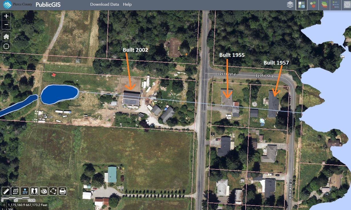
Prior to 1955, 47th Avenue was built and the ditch was an underground concrete culvert. Land between Bingham Road and 47th Avenue was divided into lots. In 1955, a house was built at the corner of Bingham and 120th Street. The drainage culvert was directly beneath the house. Again in 1957, another house was built on the corner of 120th Street and 47th Avenue, It is also on top of the concrete culvert.
In 2002, the neighbor across Bingham where the drainage ditch runs underground, built a storage building on top of the drainage culvert.
So all this begs the question, what if someone breaks the culvert driving equipment over their property? Apparently, in crucial times, owners have not been aware, nor the planning department aware, that something underneath the ground in that location that could be a hazard if it breaks. Could it be possible the County actually was aware when they allowed that construction? Or did old records get lost at someone’s potential peril?
Yesterday, I had a conversation with Arlene, owner of the property where the drainage ditch begins. Her concern was clear. If the concrete culvert is damaged or cracked, will the County force its removal or close the drain, flooding her property and the neighbors once again? Is the County preparing a solution since they hired a consultant to identify all these lost drainage systems a few years ago? At the time he was hired, I admit to making an effort to contact him and be sure he made it out to see Arlene about the ditch on her property while she is still around to tell the story of the farm her husband’s family started.
Now, what will the county do about this and others that are out there? the photos below are from the Public GIS today (1-11-24) showing the Federal Floodplain and the thin blue line is the drainage culvert.

Currently the County is also in the process of permitting a car wash business at the corner of 116th and Canyon Road that asked for a variance to build within 20 feet of the wetlands. Those wetlands would also be affected by rising water if this drainage ditch is closed due to damage. Some decisions need to be made before the path of impact by this ditch affects even more people and businesses in the area.
Midland and Summit are fairly flat, have lots of close-to-the-surface ground water and layers of clay soil that slow drainage. I know, because I grew up on Canyon Road and remember pastures flooding behind our houses and the basement in our home filling with water at times. I remember the hole in the ground from an old cesspool that we had to stay away from. My parents had several conversations with contractors and the County over the soil and water situation in the area.
This is a “to be continued” story. The ending may lie far in the future. But this affects two watersheds the Puyallup and Chambers Clover. Rain and surfacing groundwater can present a peril. We need water, we like to control water, but water may have its own plan.
