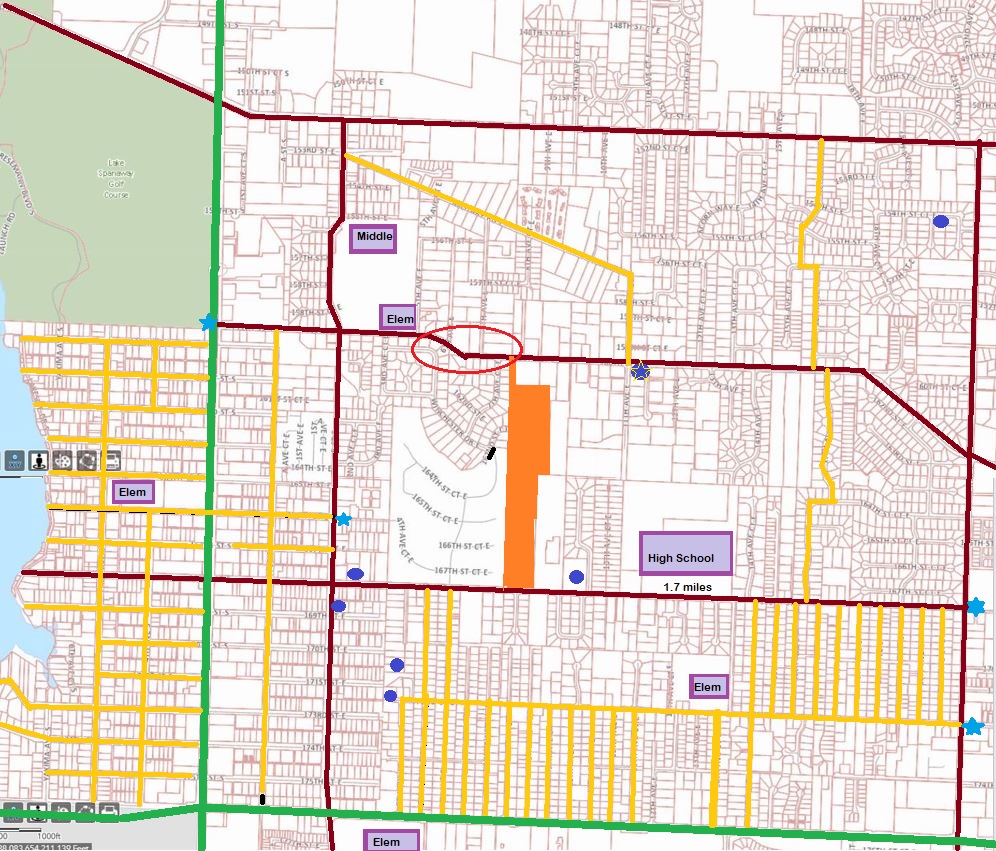
In the course of discussion over rezoning Spanaway and other nearby communities with the County Council this past month, I created a graphic. I want to share this with you. It is the roads that get you between places in the central part of Spanaway.
In most cities, there are streets and avenues. Remember that game in Elementary School? Kids stand in a group with arms stretched out, one person is a cat and one a mouse, another is a caller who says, streets or avenues. Everyone turns the other direction, making it harder for the cat to catch the mouse. (My Girl Scout Troop played it.)
Well, Spanaway doesn’t have enough of those. I calculated it takes 1.7 miles for me to get to Spanaway Lake High School and I live directly north of it on Military Road. If I walked through the gap in the back gate of the school, it is only half a mile. On the map, maroon is the color of arterial streets. Yellow are roadways that are not arterial, no center line or they go through housing developments. Green lines are major thoroughfares. The red circle was the 4th six week road closure on Military for a new sewer connection this year.
Between 176th and 172nd Streets, there are many connectors. You can walk in that area near Evergreen Elementary. Part of 168th to 172nd is walkable. But Military Road to either 152nd or to 168th has no connectivity. Walking or driving, you have to go to B Street or to 22nd Avenue unless you want to wander through a housing development. Around the east side of Spanaway Lake, you have a better chance of walking the area and getting to know people.
The point of this map, was to explain to the county how they keep us from becoming a community. That is, if we can’t walk around our neighborhoods easily, including having no sidewalks, how are we supposed to get to know each other? More so, how could they ever expect us to give up our cars and ride the bus? We have to have our cars just to take our child to a friend’s house.
It is issues like this that counties are not good at. They have a pot of road money and they have to spread it all over the entire county. Spanaway is not a priority even when your one council member (of seven) understands.
So take a look and help us figure out what we can do to make this better. Can the big orange blob, the new development going in right now help a bit? Or will they gate the development so we cannot pass?
What is your idea of how to get around Spanaway better?

Unless you went to spanaway lake high, rode a bike to and from football practice, knew friends in the area, you knew how to get around when you drove later, I lived off of spanaway loop and 154th s, knew the safe routes, some were more hazardous than others, kids have creative ways to get to school if they were in the areas that didn’t get picked up by the bus, you had to drive down different neighborhoods to get to school