Editorial: Marianne Lincoln
Is water an inconvenience? Apparently, if you are an official developing Pierce County, it is.
First, I must say, this is nothing new. Developments in Pierce County have been moving water out of the way for a very long time. Here is a litany of examples:
- 1853 a dam was constructed at Lake Steilacoom.
- 1863 Peter Smith built the Smith Ditch west from the Spanaway Loop farm over McChord
- 1870’s Captain Ainsworth (of Fort Steilacoom) moved Clover Creek to the south end of Lake Steilacoom
- 1880’s water was diverted from Tule Lake for Charles Wright and City of Tacoma
- 1890’s a dam was built in what is now the Breeseman Forest and the lake briefly fed water to the City of Tacoma in a wooden tough to the Yakima Avenue retention pond that now is near Lincoln Park and I-5.
- 1950’s a dam was built at the mouth of Chamber Creek – correction to 1918 when an earthen dame was created (coutesy Al Schmauder)
- 1957 and overflow structure was built by the US Army Corps of Engineers (USACE) to control American Lake levels
- 1953-54 twin culverts re-routed Clover Creek on McChord Air Force Base
- 1960’s Clover Creek was rechanneled into a concrete culvert from Pacific Avenue to Spanaway loop Road
- Undated creek runs through Parkland from A Street under Pacific Avenue in ditches along streets (106th/Yakima) to a retention pond near Christensen Elementary
- 1960’s several water flows were culverted for the construction of I-5 and SR512
- 1966 Pierce County built a high flow concrete bypass on Clover Creek, by 1968 it became the main creek, bypassing the old creek bed through Pacific Lutheran University
- 1970’s McChord AFB built a dam on Morey Creek
- Since the 1980’s Pierce County has been building residential stormwater retention/Detention ponds
- 1930’s to 1970’s Substantial groundwater rights for water supply withdrawals were granted
- 2000’s the Washington State Department of Ecology (WSDOE) granted a water rights transfer from the Abitibi Mill to Lakewood Water District
In addition to all those major changes, logging, deforestation, pastures, urban roads and sidewalks, draining and filling of wetlands have also been occurring.

Contamination of our water resources from human sources like hydrocarbons (like exhaust, grease, antifreeze, oil), trace organics, heavy metals (zinc from tires, copper from brake linings), fertilizers (nitrogen, phosphorus), herbicides and pesticides from lawn maintenance and golf courses have also been occurring. Pets and farm animal waste, septic systems and wastewater treatment also add to the contamination. Parking lots and non-pervious surfaces (rooftops) add to contamination. Signs of some of these impact are the algae blooms in many lakes.
Still, more is happening right now with the new zoning passed in December called the Town Centers and Corridors package to the Title 18A and 18E developments regulations.
Planning and Public Works were placed together under Pierce County Director Dennis Hanberg around 2016, shortly after the election of Executive Bruce Dammeier. In 2020, there was a failed attempt to also place the local health department also under the County Executive. The Critical areas portion of development regulations is currently handled by the Tacoma Pierce County Health Department. By consolidating the power of the health department with the County Executive, he would have an exclusive ability to dismantle all critical areas and management of the health of our water resources.
Pierce County Planning and Public Works currently does not have a department devoted to ecology, nor do they have any staff that are qualified hydrologists. In the past, much of the wetlands delineation was done by unskilled staff, creating benefit to those wishing to create more dry land on which to build.
The County has an Environmental Services Department which conducts surface water management projects, design and technical assistance.
Here is the bigger problem. Many on the Pierce County Council in recent years have considered our water system a surface water management problem. They have built retention ponds and redirected water flows, calling them stormwater runoff. They have empowered themselves to describe seasonal creek flows as runoff instead of part of our ecosystem. I am certain a salmon awaiting the September rain to spawn isn’t thinking of that as winter weather runoff. They want a creek flow to come up and leave their next generation.
What we end up seeing is places like 208th Street between 30th Avenue and 38th Avenue, where the Frederickson Industrial Area was expanded and Sierra Pacific allowed to scrape off the entire pasture surface including a year round water flow and bury it in a pipe to a stormwater retention pond. They got away with this because the construction of 192nd Street years ago blocked that water flow from arriving at Stony Lake and on into the Clover Creek water system. Frederickson Lake, Stony Lake, the Oxbow and Clover Creek used to be all part of the same water system. It included water that moved underground, which is why Frederickson and Stony Lakes rise after a significant amount of rainfall.
There are a few of us in the County documenting these travesties. We take photos each year of rainfall events and places where water moves on the surface. We take photos of what the county does when they are disrupting these flows to make more dry land to build on. Occasionally, a month of heavy rain surprises them and houses go underwater, because they have no hydrologist telling them how that sole source aquifer moves underground, still connecting the waterways they downgraded, beneath the surface. A great example is the oxbow between Military Road and Waller to 22nd Avenue. Someone in the County did not do their homework and houses between 161st and 159th Streets went underwater. The history of the Bethel School District notes that Clover Creek Elementary closed in 1956 because the farmer who owned the land lost his house to the flood in the location and he moved into the school building as his home for a few years. That school building was a cabin just north of the intersection of 22nd Avenue and Military Road. The last remains of the cabin were removed by the Akers family around 1996.

My comments here are part history and part warning. As long as Pierce County continues to downgrade streams and waterways in the county, scrape them off the surface and channel them into pipes and manmade ponds, we will never restore our fish runs. The fish and wildlife in Pierce County will continue to suffer while developers make and spend their millions. We cannot pretend to care about our rivers if we do not care about the streams that feed them. Those streams provide the insects, grubs, fry and other wildlife whose presence round out the ecological cycle. We must care more. We must develop processes that allow the water to flow the way it needs to. Our aquifer must recharge from the rain that falls. It cannot get to the ground or wells if it has entered a pipe that send it straight to a river.
I am grateful Councilwoman Pam Roach stopped the change of control of the health department this year, but our work isn’t done. Nearly all the money electing our County Council and Executives comes from people and businesses in the construction and development business. Most are far more interested in making money than saving the environment. Often the County leaves them to their own will on remediating their properties where environmental concerns exist and Washington State is not being studious on follow up as well.
Watchful citizens, aware of the regulations have caught travesties in progress. Some projects were reported and red tagged. In other situations, citizens were threatened or prosecuted by vindictive developers intent on getting their way. Citizens are not protected when they report developers breaking the law.
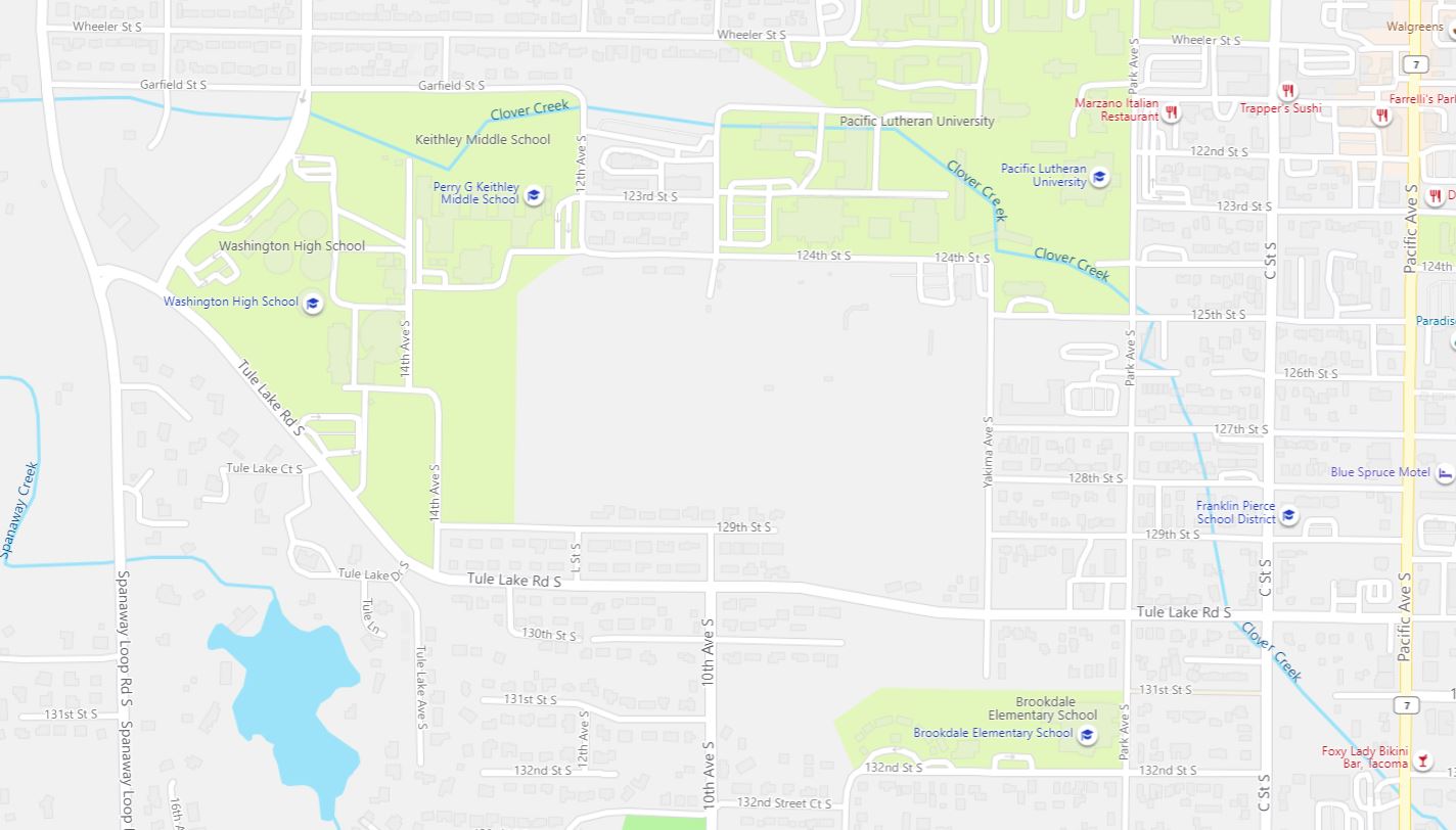
Yet, as citizens who elect our representatives, it is our duty to be watchful of the changes that are being made. I have written this for everyone who has not lived here their entire life. Take a look along 125th and Park Avenue. See if you can spot where Clover Creek used to flow. Take a look at the historic reference document link below. It shows the culvert being placed under McChord AFB. Decide if we are adequate stewards of our environment or if we need to stop the insanity of thinking we know best where water should be.
These are historic soils map photos, but they show water movement before I-5 and SR512 were built.


References:
Title 18A Development Regulations – Zoning
Title 18E Development Regulation – Critical Areas
summ. of overall landscape and human changes in ccwc last 150 years_201208211826219270 (PDF)
https://www.co.pierce.wa.us/DocumentCenter/View/70533/Chambers-Clover-Historic-Flows- (PDF)
Soil Survey of Pierce County Area, Washington USDA 1979

The dams on the lakes that Clover Creek feed into are dammed to provide year round water level control for lake front property owners. The dams stop all returning Salmon from returning to natural spawning beds, where the creek has not been channeled for development. The dams stopped all returning Salmon to the upper reaches of Clover Creek. All efforts to put in a fish ladder are met with resistance from government and residence along waterfront property. Why is it that we talk of salmon recovery and resist allowing nature to work. True we have hatcheries but we also have Indian nets that strip the rivers. One hand works against the other for procreation and both complain.
This article recaps a sorry story of how we have “managed” our water. The Chambers-Clover Watershed Council is working to create a method to report annually on the status of our groundwater and the impacts on stream flow caused by water withdrawals. So far this information is non existent. The USGS was hired to develop a model of the watershed. Unfortunately, the mode is a huge monster requiring massive amount of data and is not useful to inform citizens about the status of the groundwater and stream flows or to identify trends. We welcome any volunteers who have a passion for this effort to help us.
Al, Stewardship Chair, 253-202-2486
Thank you Al. I have been trying to track some of the underground movement sine 2017 flooding in the Pioneer Valley Area. Where it is flooding and not flooding in January 2021 has been a surprise.
-Marianne
Received from Kurt Reidinger
List is a good start. Lots of stuff to account for, verify, and possibly add to the list. For example, Andrew Byrd’s mill appears on an 1855 U.S. Army map, so 1853 is probably close (need to check DLC records at TPL). You’d want to add A.J. Knicht’s DLC filed in 1853 (so work may have been done in1852 before he filed) – he drained the small lake where Lakewood Town Centre now stands. Peter Smith did much drainage work over the years & lawsuits were involved – his case needs much research. Ainsworth, a rich Portland industrialist, had his caretaker work on diverting the creek when he acquired the property from the Boatman’s around 1878. It was a troublesome diversion (Boatman may have started it but I’ve not found such evidence yet). City of Tacoma is a big one as they diverted water out of the watershed from around 1885 to about 1912. First Spanaway Creek, but as population skyrocketed (due to Ainsworth et. al. railroad building) they took from Clover Creek, Tule Lake, Crystal Spring (northern trib to Smith Lake), railroad tunnel seepage, and started drilling wells, too. Then they abandoned the watershed and things sort of returned to normal (Peter Smith even tried to sue Tacoma for not taking the water which caused flooding on his property).
Much of the stuff done in the 19th century and early 20th century was small scale and probably correctible. For example, Peter Smith’s channization could be re-meandered and a natural stream restored. The Clover Creek diversion could have been filled in and the small lake could have been re-built on the Villa Academy marshland before the 1950’s and the Villa Plaza shopping center. But I don’t think you can do anything like that now for the Steilacoom Lake inlet. Same with the Steilacoom Lake outlet and Pierce County’s disastrous concrete box culvert dam that washed out the channel starting in the 1930’s. Correcting both would require serious money and engineering. Same with the burying of Ponce de Leon or Davidson Creek in the post-WWII period. Are you going to buy all those houses and daylight the creek?
It continues to this day. Witness the industrial truck development on top of the north tributary to old Smith Lake and Clover-Spanaway (vicinity of Crystal Spring on NE of McChord Field). Pierce County needs to be shown in detail where it screwed up. Maybe it will make them think through the consequences of their development policies.
Just trying to find out information about why Clover Creek is not running in front of our condominium anymore. So many questions out there but not so many answers. I really appreciate your information on the subject. It was dry this summer for three or four months. Just last week it started to flow again. Now it’s slowing down to nothing again. I know we had rain but that doesn’t make any sense. I live on Clover Creek at the intersection of gravelly Lake Dr. and 112th St. It sounds so complicated I don’t know if anybody could straighten it all out.
McChord Field was working on the culvert under their runway this past summer. I have photos from Bing Maps that show the work going on, but I can’t put them in comments. Look there and see for yourself. It has not been uncommon for Clover Creek to go dry in the summer from B street and 136th onward through the culvert in Parkland. Morey Creek and Spanaway Creek contribute water that usually fills it in your direction.
However, beavers were introduced at 25 Avenue East, east of the development project at the former Brookdale Golf Course. We locals suspect the developer authorized their introduction as they had much work to do on water flow through that project. Residents in the area spotted them being released from a company that moves wildlife. It is said they were from King County. No one has admitted directly being the one who agreed to the beavers release. It is exasperating. That development is frustrating us who try to keep these types of construction under some scrutiny.
Thank you so much for your reply. I feel that you’re the only person that knows anything about Clover Creek. It is actually flowing now. I guess I should be happy but I don’t know if the fish are coming back. Again, thank you for your comments.