[Editor note: Letters from a Chambers Clover Watershed Committee (CCWC) thread, a public Pierce County Committee that discusses the watershed, but to the frustration of some, does not take actions. (A different activist group would have to form to take on those tasks.) There is concern, but there is not a solid plan or investment in dealing with the problem. Marianne Lincoln]
****************
Hi Al,
Mike Nollan here. We haven’t spoke for a while but I saw you on the CCWC Zoom meeting and thought I’d touch base. I sensed your frustration with a lot of meeting planners and no action doers… To keep you up to date on my activities… I have filed several documented complaints on the SeeClickFix website https://seeclickfix.com/web_portal/TKWgpFXYKgCQQaGg9fixGNSh/issues/map?lat=47.13695755896396&lng=-122.37688064574975&max_lat=47.16993551407006&max_lng=-122.29396820068149&min_lat=47.103959138467616&min_lng=-122.459793090818&zoom=12
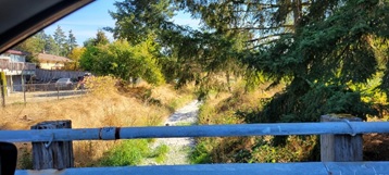
and nothing is being addressed there either… The map is flaky as some issue dots disappear and reappear as you zoom in and out of the map… but, I sent the county a map of the now 6 known beaver dams between 25th Ave E and 20th Ave E that are holding water upstream, flooding private properties year round, reducing and stopping water flow downstream and generally degrading the creek system from 25th Ave E to JBLM.
Here are the numbers of my complaints on that site regarding beavers, flooding of my property, stream degradation at 138th, heavy flow at my place for weeks and none at the Forterra property just down stream and water diverted out of the creek channel and on to county owned property flooding 20th Ave E eroding the asphalt and flowing back into the creek channel.
13917358, 13917485, 13933599, 13917148, 13939802, 11515861, 11696985, 11635767
I offered to take Barb Smolko up to see the dams first hand… no response. I have been unable to determine how many beaver dams are between the Brookdale development and our house off 11th Ave E but historically there have been three big ones. The silt build up this year has been tremendous. I just get this feeling that the county WANTS the creek out of its banks and into the aquifer recharge zones and wetlands to amend the alleged ‘historic low aquifer’, allowing them to permit more development. My property has flooded the last three years in a row and the neighbors are shocked since they only recall it flooding only once prior. The crapping up of the creek channel downstream and the already flooded recharge buffers upstream looks like its creating a perfect storm for another year underwater…
It just looks like nothing is going to give… for a very long time. Just wanted to let you know I recognize you have been at this ages longer than I and I applaud your tenacity.
Mike Nollan
****************
Hi Mike,
I really appreciate you sending me the beaver info.
Beavers have been a problem for some years, but they apparently are not working out well with people living near the creek.
The flow in Clover Creek has stopped in the opens space land managed by FORTERRA which is upstream from 138th St.
Beavers are apparently blocking the flow and causing the water to flow over the creek banks to recharge the shallow aquifer.
As you infer, this is not all bad because the shallow aquifer needs to be recharged to support surface flow in Clover Creek. Even if the beavers did not block the flow, water would likely infiltrate into the shallow aquifer in the area around 136th Street. This results because there is no separation between the shallow aquifer and A aquifer and maybe the C aquifer. Until these underground water storage areas are full of water, Clover Creek will not flow.
So, what is the correct remedy for too many beavers?
– In many instances like this in the past, the creek side landowners open the beaver dams. This causes a high temporary flow of water down stream and flushes any fish and aquatic life downstream. Soon the downstream area which was flooded dries up and all aquatic life is lost. The habitat created by the beaver dams is also destroyed. In a dry year or summer, the beaver ponds are the only refuge for native cutthroat and water critters.
– An effective alternative is to install beaver deceivers. This is a pipe which is installed above the dam to move water to below the dam. It is placed so the pond level stays at a certain level. It does require monitoring and maintenance if the beavers figure it out. The Pierce Conservation District may be helpful for these types of projects.
– Due to the flooding issues which results from the full beaver dams when rainfall is high, you may get some ideas or help from Pierce County Storm Water. Tom and Tim cced above are in this business.
– In the case of beaver problems occurring on JBLM they just shoot the beavers. Sometimes a beaver trapper is hired with approval by WDFW and the beavers are resettled.
– There is no easy answer. Mother Nature has a plan and we humans usually screw it up trying to fix things. We think we are solving one problem only to learn we created another.
Stay in touch,
Al Schmauder
****************
Al,
Attached aerial image shows the 1941 landscape in that vicinity. [Editor note: No image was in my thread.]
It looks to me the creek was split into two channels probably to accommodate farming, i.e.,
two smaller channels on either side likely reduced flooding impacts and gave better access to alluvial soils in the creek valley.
The split appears mainly on Henry Johns’ DLC (no. 47). You can see the Brookdale Golf Course upstream on Christopher Mahon’s DLC (no. 48).
USGS noted the DLC numbers on their 7.5 min. topos as late as the 1960’s as shown in the attached map excerpt.
Anyway, an early survey map (before the DLC’s were mapped) suggested a single channel.
A logical and more lasting “fix” would be to consolidate the two channels into one and plant willows & alders along the single channel,
possibly placing red cedars and other conifers in the valley to ultimately suppress and shade out the invasive reed canary grass
as well as other invasives. Big job, though.
Kurt Reidinger
[DLC = Donation Land Claim, USGS = United States Geological Survey]
****************
Kurt,
I believe that the crop grown was hops (for flavoring beer).
Also I have observed occasional groundwater flooding of the depression between the two constructed stormwater/irrigation channels, but more frequently drying of the streams on both sides of that depression.
What is needed is surface/ground freshwater quantity and quality management instead of the PCSWM exclusive preoccupation with getting ride of this precious resource by shunting it off via stormwater runoff drainage ditches to Puget Sound as quickly as possible.
Don
****************
Good morning!
Can anyone out there in reader-land fill in ACCURATE elevation at the points indicated in the attachment ‘2023-01-31 (32)’? If they are land surface elevations I can measure the distance to the creek bottoms… I believe the distance between 1 and 6 is 2.3 miles.
It’s not my intention to get Clover creek to just dump all of it’s water into the Puget Sound as quickly as possible to avoid seasonal flooding or the other ‘natural’ creek behaviors… I just find it incredulous to believe that it’s a good idea to allow beavers to literally STOP the creek flow and divert all of the surface water onto private properties and canary grass fields, year around, via the construction of more than 9 dams on a basically flat section of creek thinking it is doing anything to ‘protect the resource’. I don’t understand how the creek is ‘losing reach’ when we allow it to be unnaturally stopped by beavers, regardless of how they got here. When beaver dams slow and stop the water flow, the silt and muck congeal and fill in the creek channel. The ‘deep pools’ of cooling water (even those behind beaver dams) are being converted to shallow silt filled heat sinks. On the attached image, the muck on the left portion is over 2′ to 3′ thick. Deep pools created by beavers would be welcome if the water level from their dams didn’t waste water flooding acres of grasslands in the process or stop the creek.
Take care,
Mike Nollan
****************
Mike,
The key problem is that groundwater, on which the creek is highly dependent, has been overallocated. Ecology failed in its mission to protect streamflows.
A corollary is that Pierce County permitted excessive high density urbanization of the creek’s valley, also leading to excessive demand for groundwater along with destruction of the creek’s riparian zones.
Both agencies essentially threw up their hands. They basically tacitly conspired to destroy the watershed’s environment and ecological integrity by looking the other way in the face of development.
Beavers are a ‘keystone’ species and confer many benefits on the environment, particularly for salmon. Numerous projects across the western U.S. are focused on restoring beavers.
This has even led to constructing ‘beaver dam analogs’, i.e., fake beaver dams that function as ponding devices. Example scientific paper on beaver-steelhead trout interactions attached.
FYI, Clover Creek once had a healthy steelhead population and was the source of the state’s program to artificially propagate the fish throughout western Washington. The hatchery program was abandoned after it was realized it was counterproductive for a number of reasons. The emphasis now is on protecting and enhancing Puget Sound natural populations which are designated Threatened under the US Endangered Species Act. Portions of Clover Creek and tributaries are now designated critical habitat in that effort: https://www.federalregister.gov/documents/2016/02/24/2016-03409/endangered-and-threatened-species-designation-of-critical-habitat-for-lower-columbia-river-coho#p-310
A short video: https://youtu.be/DSRpzPzZQs8
Kurt Reidinger
****************
Wow ! The UTube video about beavers was really enlightening. Mike the aerial photo you provided shows how the beavers are creating a large wetland and green area.
Makes me think it may be a better policy to promote the beavers and buy out the homes that may be flooded.
Al Schmauder
****************
Evan,
“Pierce County growth has exceeded our natural resource. Sustainability should be the primary focus. “
Ryan should know that a lot of people are beginning to realize the above quote.
We are waiting for a recent USGS report to confirm this condition.
Clover Creek no longer flows in Parkland for up to 8 months out of 12.
Lakewood Water District is selling tons of water to upstream water companies so more residences can be supported with water. The local companies are out of water.
Planning for more growth is not coordinated with the available water supply.
Does the Community Village proposal have approval from water suppliers?
This topic needs to get more attention, soon.
Al Schmauder
****************
Al,
The below first stated excerpt from Kurt’s response is a true and factual statement about failed governmental agency stewardship of the Chambers-Clover Watershed.
However, I do take exception to your second highlighted statement.
The Chambers-Clover watershed was a low gradient Oregon White Oak grassland prairie where the shallow aquifer groundwater level was just below the land surface during the dry season and above some of the land surface during the wet season. So much so that any depression was filled with exposed groundwater year around. During the fall/winter wet season the groundwater level would rise (groundwater flooding) above the land that separated these numerous groundwater filled depressions and intermittent in stream flow stream reaches thereby creating “over land” salmon access to and egress from wet season groundwater discharge sediment cleansed gravel bottom stream reaches and lake bed spawning and rearing habitat.
This was not a natural habit for beavers. They inhabit areas where running water stimulates their dam building instincts and food is readily available as a result of their ever pond’s expanding riparian zone.
Fast forward.
White, mostly European immigrants, invaded and changed the landscape and hydrology by digging drainage ditches to expose for farming the fertile soil contained in once numerous groundwater filled pot hole depressions. They dug wells to access the fast disappearing surface water for drinking and irrigating. They planted beaver edible trees to the extent that they converted what the Tribes had stewarded as a grassland White Oak savanna for eons as prime Coho and Sockeye salmon and Puget Sound Steelhead trout habitat into beaver habitat. Beavers joined the “whites” as invasive species and began their own adverse hydrological and biological modification of the Chambers-Clover watershed.
Unfortunately, many of these beaver created ponds are constructed in areas underlined with a till layer (aquitard) that prevents infiltration of water contained in these ponds to recharge the underlying shallow aquifer. Thus these ponds expand laterally to inundate adjacent landowner property as experienced by Mike. This is not a natural condition. It is the result of an invasive species (i.e., immigrant humans and opportunistic beavers) induced adverse hydrological and biological changes in our watershed. It is now unfit habitat for salmon and progressively so for humans.
Meanwhile, beaver ponds and PCSWM detention, cleansing and infiltration ponds are not being constructed above discontinuities in the B (D, and F) aquitards that facilitate retention of wet season precipitation and dry season infiltration to maintain shallow aquifer groundwater level high enough to sustain in stream flow in the lower McChord to Lake Steilacoom reach of Clover Creek.
It is in these area where there was once an upward flow of groundwater from the C confined aquifer into the A1 and A3 shallow aquifers, now reversed (downward flow) because of excessive withdrawal of groundwater from the C and E and G aquifers for domestic consumption. This is the reason that the middle and lower reaches of Clover Creek go dry for months now. Even groundwater discharge and in stream flow in the Spanaway Creek reach of the Chambers-Clover watershed is being adversely affected.
This is a harbinger for what other Puget Sound Basin rapidly developing watersheds are becoming. Learning form our mistakes, i.e., adaptive management, is promised by our governmental agencies but sorely lacking in practice.
Managing (stewarding) the quantity and quality of our watershed’s limited, declining and increasingly polluted ground/surface freshwater resource is the responsibility of the Department of Ecology. So far it has failed to perform its Federal Clean Water and Endangered Species (salmon and humans) Acts assigned responsibilities and exercise its authority when it comes to overseeing the management of Clambers-Clover watershed’s freshwater resource.
Likewise Pierce County has failed to comply with the legislatively mandated intent of GMA, SMA, SEPA and its Critical Area Ordinances as amply demonstrated by the proposed siting of Tacoma Rescue Mission’s Village project and the City of Lakewood’s Ecology sanctioned aluminum and sulfate/sulfide pollution of Waughop Lake.
Don Russell
Aquifer graphic:

