By Marianne Lincoln
It all started with Muck-Kapowsin Road. It isn’t called that anymore, it has a number like most other roads in Pierce County. It is now 224th Street. It runs from Elk Plain at the Mountain Highway through Graham and Thrift and on to “The Country.”
Roads in the area were often named after the people who built them, usually the farmers and land owners that lived on either end of the road and started a trail to get to the market. But Muck-Kapowsin was not named after a settler. In fact, the road does not go to Kapowsin, the historic logging community named after a local Indian, according to legend. The road also does not go to Muck. There is no place called Muck, at least, there hasn’t been since 1853. And the military base took over the west side of the Mountain Highway and there is no road through at 224th.
So as I sat at my desk at Bethel High School, I resolved one day to get to the bottom of the mystery. Fast forward almost 30 years as the County was working on a Graham Community Plan. The plan was actually Elk Plain and Graham, but Elk Plain did not get their name in the title. I lived in Elk Plain at the time, so I volunteered to work on the history portion of the plan. Along with Bud Rehberg of the historic Bennett family, Cecilia Svinth Carpenter of the historic Ross family, Eleanor Leibrand and her sister Laura Jobe and Andy Anderson, author of “In the Shadow of the Mountain: A History of Early Graham, Kapowsin, Benston, Electron, and Vicinity.” The committee inspired him to complete that book that he had been working on for 10 years, it is now out of print. The link to the plan above has a little of the area history in it.
We researched Kapowsin, whose high school Eleanor and Laura had graduated from. We studied areas on the map called Benston, Leber, Thrift, South Orting, Electron and Clay City. And then, we discovered Muck.
Muck was actually outside the plan area, so we learned about the former employees of Fort Nisqually who settles on Muck Creek within the plan area. That included John McLeod and William Benston. Across the Mountain Highway from the McLeod place is Bethany Lutheran Church, founded by Cecilia’s father Hans Svinth. It was formerly another farm owned by John McPhail from Fort Nisqually, and friend of John McLeod. In fact, it turns out John and John were both from the Hebrides Islands in Scotland, an island called Lewis. Another island in the Hebrides is called Muck. There is also a Chinook jargon word muck-a-muck, which means food.
Though we actually don’t know if the Indian term or the island name were responsible for the naming of the creek, the name was definitely changed to Muck from it’s first Hudson Bay name of Douglas River. Still, that does not explain the road. The place actually called Muck, was a farm that Hudson Bay Company (HBC) opened in what is now JBLM Range Area 13.
After fur trapping slowed, because the animals were trapped almost out of existence, Fort Nisqually took on a venture in about 1843, a separate business called the Puget Sound Agricultural Company (PSAC). With the products from the farms, the Fort, which was more like a general store, started to supply new settlers that were coming in from the Red River area of Canada, in hopes the Oregon Territory above the Columbia River would become part of Canada. In 1946, that changed with the boundary negotiations landing at the 49th parallel. but the business continued a few more years until Washington became an official Territory in 1853.
Muck Station, as it was called, was first located near the place that Eastgate Road intersects SR507 to Roy. A couple years later, it was moved to what was called New Muck, about a mile east of Old Muck. The station consisted of a large barn, several contracted employees and livestock, mostly sheep, but also pigs, cows and horses. The locations both have old apple and pear trees on site to this day.
In 1849, the California Gold Rush caused several Fort Nisqually contractees to abandon their contracts and head south for some of the riches. In 1850, some came back, a bit richer, but many were not rehired by the company. They instead declared themselves American citizens and proceeded to settle on land on Muck Creek they could later claim as a Donation Land Claim. Although the company called them squatters, Dr. Tolmie did not have any power to evict them.
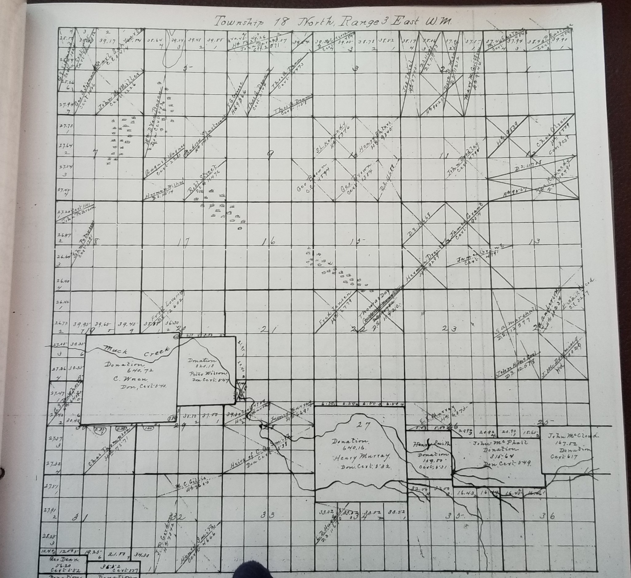
When Washington Territory came into being in 1853, several things happened. First, the Indian Treaties. The first American settlers to cross the Oregon Trail branch known as the Naches Trail took place in the end of October. Then, Fort Nisqually declared that the Hudson Bay Company (and Puget Sound Agricultural Company) were not British government, they were a Company and that Washington State and Pierce County had to pay for their land in order to make them leave. That purchase was in court until 1869, when a settlement figure was finally reached and HBC left for Canada. It was then, in 1871, the surveyor from Washington D.C. could come out and the Donation Land Claims could finally be awarded to those who were living on them. Normally, a DLC was awarded after 5 years of living on and working the land, but the ownership was in dispute in 1855, so everyone had to wait. In that time, some of the owners had passed away Lyon A. Smith’s claim went to Peter Wilson, and Henry Bushalier’s (Spanaway Lake) claim was awarded to his widow.
Muck became the DLC of Charles Wren. He got 640 acres because his wife, Elizabeth, was a daughter of Charles Ross Sr. Peter Wilson and Henry Smith did not have white wives, so they only got 320 acres. Henry Murray was married to Christine Ross, so he got 640 acres.
So the mystery of Muck revealed itself. There is even a Muck Journal in the Fort Nisqually archives. But what about the road that did not go to Kapowsin?
As it turns out, before the Mountain highway was built, which was not until 1923, there was a road from Elk Plain that ran to the Benston place, along Mathias Road. It then ran along what is now called Webster Road, through the area where the Benston School and Post Office stood and then on to Kapowsin Lake. Over the years, those roads have been altered considerably, but you can still get to Kapowsin that way, past Camp Arnold (Glennis) and on to Meridian.

So the mystery was solved over the road called Muck-Kapowsin, yet many additional questions surfaced. Over the next year, I met a group called the Decendants of Fort Nisqually Employees Association and attended a couple family reunions for Henry Smith. People I knew and people I have not yet met were all over the county and state and in Oregon, Spokane and Victoria, B.C. with more answers and clues to the puzzle, a footprint left by Fort Nisqually on Pierce County’s south side.
Other farms of the PSAC included Spanueh Station (Spanaway), Sastuck (Parkland), and Tlithlow (Lakewood). Now there is also another incredible story about those settlers along Muck Creek and the Indian War of 1855-56. I will leave that for another time.

Thank you so much for this! I recently solved my own Muck mystery looking for the old Muck hwy that went from Fort Nsiqually to the Much Station. I found a historical marker at the JBLM DuPont gate off the DuPont Steilacoom Rd.