There is a great deal of history hidden in the bushes and trails of the area south of the Tacoma borders. Although Fort Nisqually resides, reconstructed in the Point Defiance Park, its former footprint lies south of Steilacoom in the city of DuPont. In fact, it had two footprints in DuPont.
The 1833 site lies within the Home Course inside a black chain link fence with a stone monument inside. it also has a cemetery to the east, with a wooden rail fence and some large stones with numbers on them. Several of those stones are of the Kittson family. William Kittson was a clerk at Fort Nisqually. John Wilkes named an island after him. That island is now misnamed Ketron, due to a sloppy mapmaker.
The 1842 site of Fort Nisqually site is much easier to see. It is also bound by a black chain link fence but is visible from Center Drive across the street from the current city hall. Along the side is Sequalitchew Creek, just before is descends to the Nisqually Reach of Puget Sound.
Fort Nisqually was founded to supply British settlers with staples and necessary equipment to start up their new farms and residences in the area of South Puget Sound. Around 1840, the Hudson Bay Company also started several large farms around the area that is now Pierce County.
These farms became a subject of contention when the United States and Canada border was officially established in 1853. HBC took the matter to court to require Washington State to buy the farms back from the British Company. That lawsuit settled in 1867 and the payment was made in 1869.
So, every family that had taken up a Donation Land Claim or Homestead in the area claimed by HBC, was unable to sell or transfer their claim until they were finally surveyed after the court case closed. For the claims along Muck Creek, it was November of 1871 when the Federal Surveyor came calling. John McLeod, John McPhail, Henry Smith, Henry Murray, Peter Wilson, and Charles Wren were the former Fort Nisqually employees whose farms were along Muck Creek, Indian name Yll-Whaltz, also referred as the Douglas River.
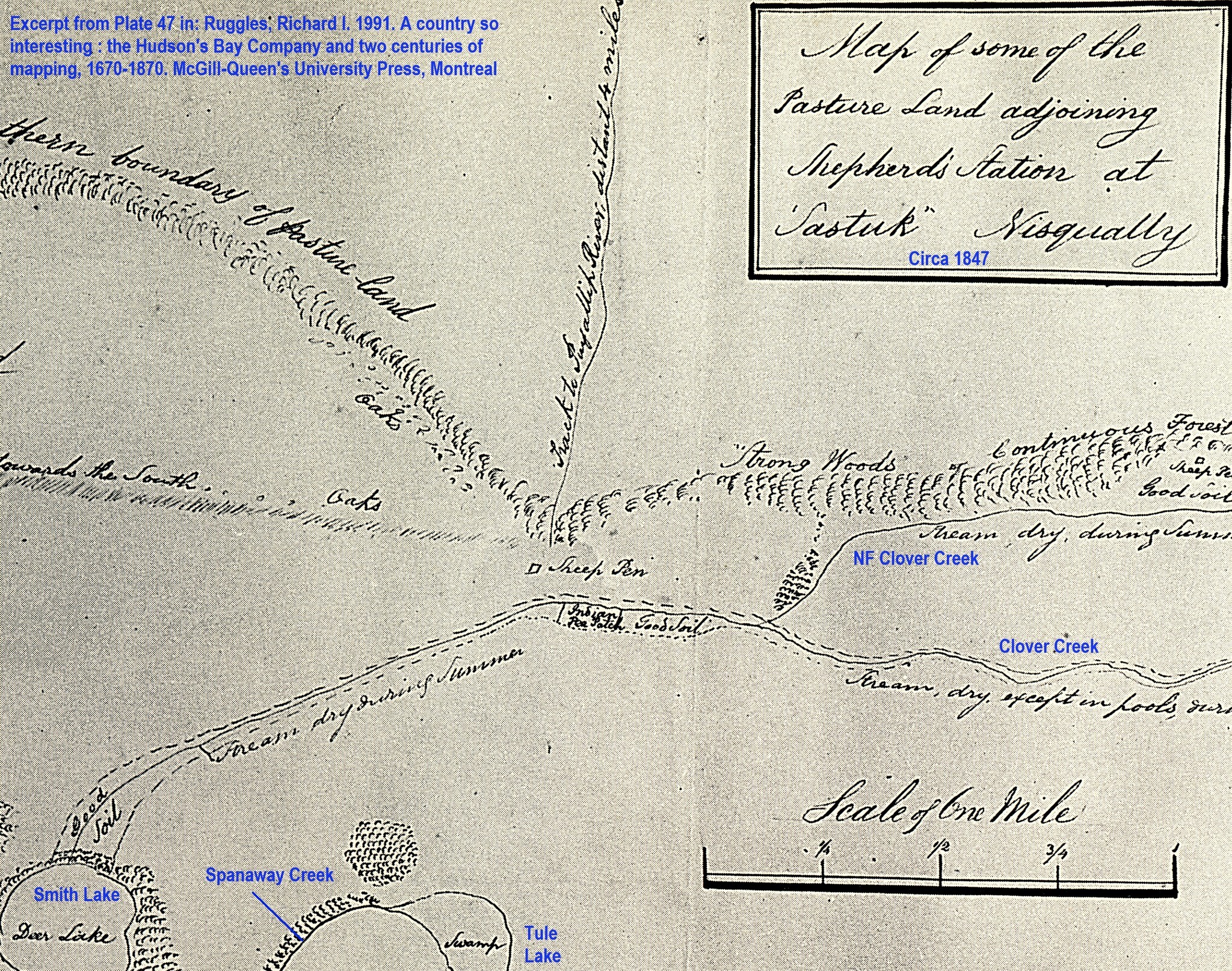
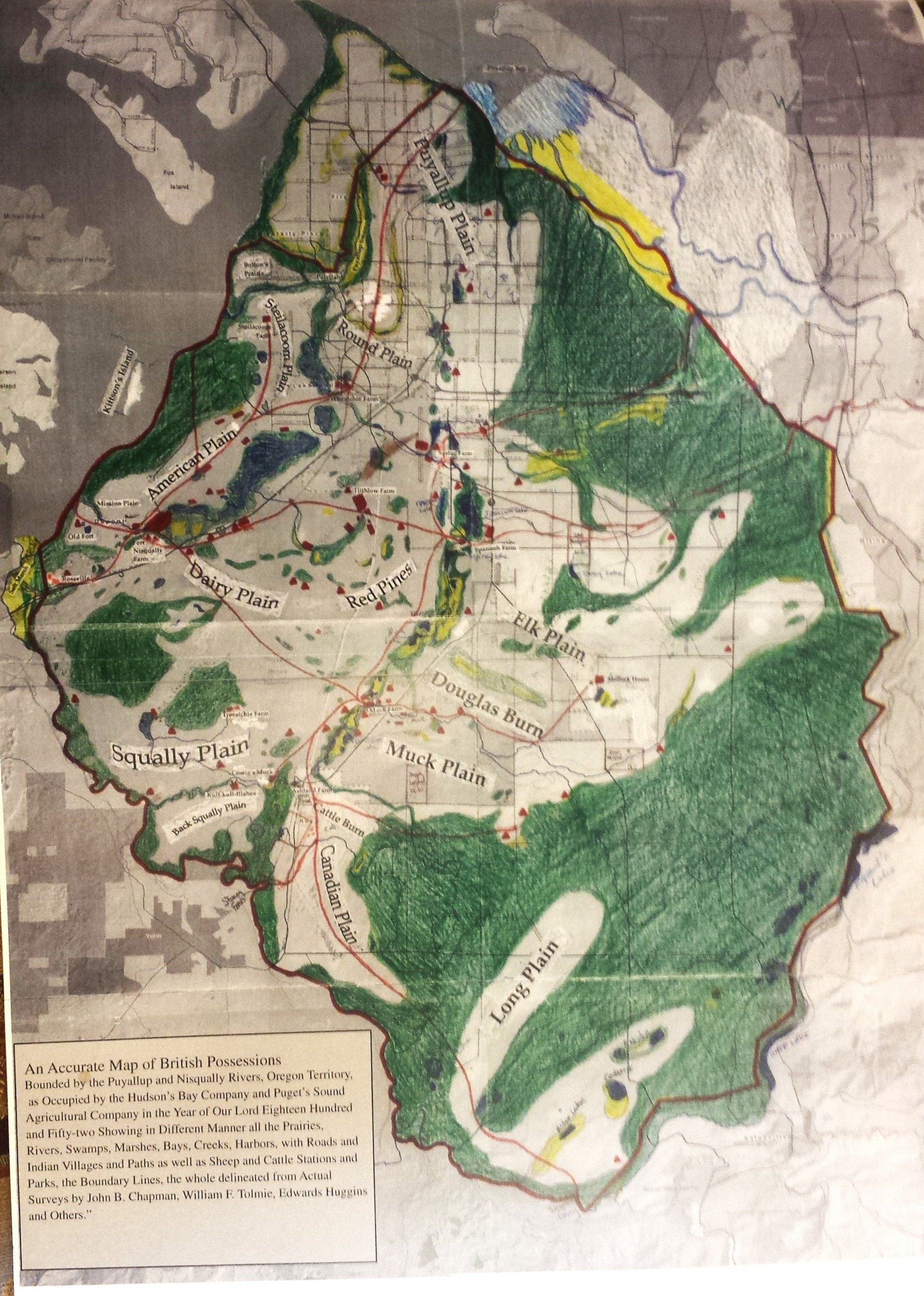
The PSAC farms in the area included Muck Station (near where Eastgate Road and SR507 cross). Spanueh Station was at the southeast corner of Spanaway Lake, run by John Montgomery. Sastuk (or Sastuc) Station was located near the swampy land that later became McChord Airfield, just west of the Peter Smith farm (later Shibig Farm). Sastuc was near Clover Creek (Indian name Solotals). The area South of Clover Creek and directly North of Spanaway Lake was a popular summer Indian camp. (PLU Golf Course) You can also see where local creeks have been redirected by development using these maps.
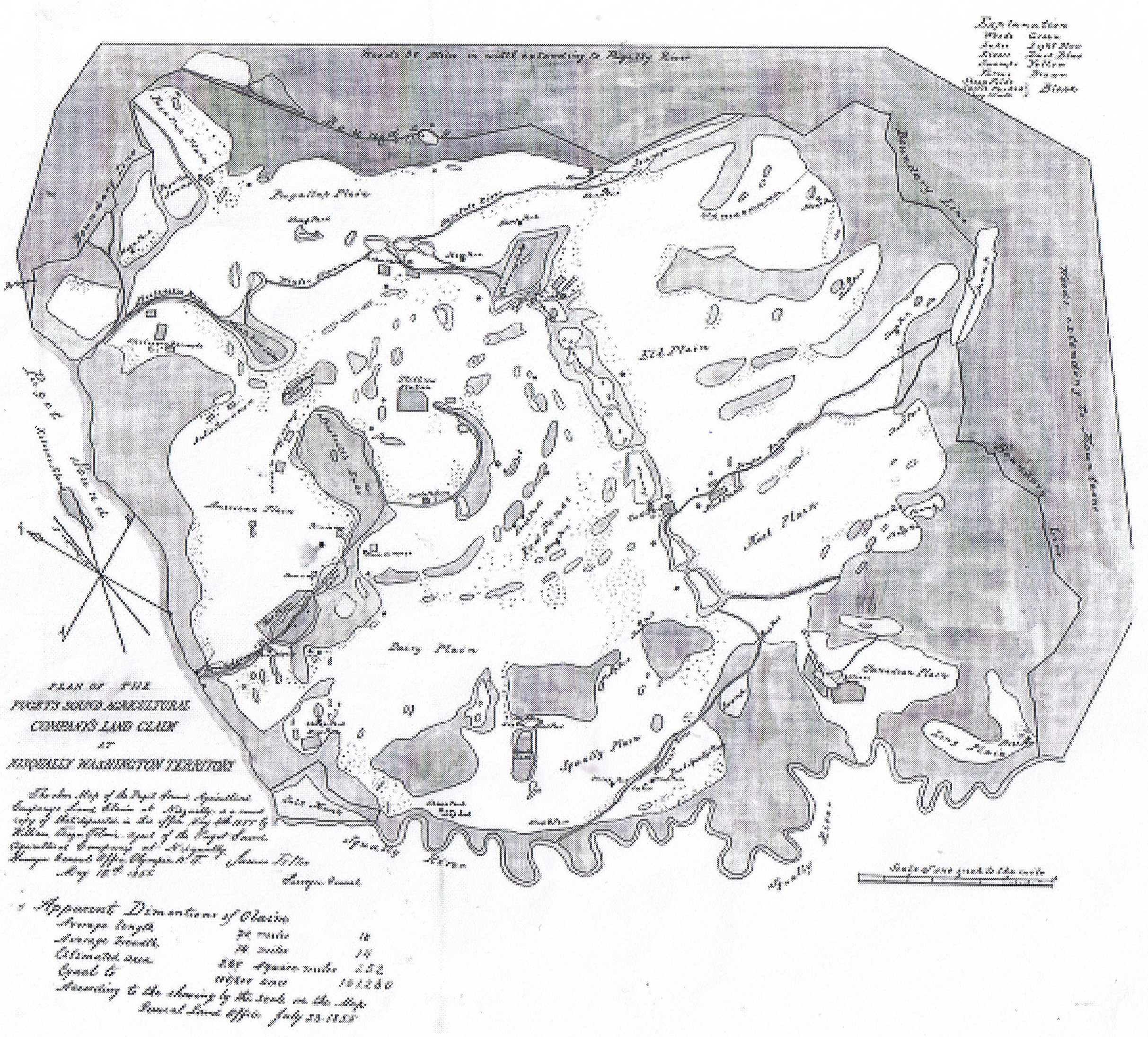
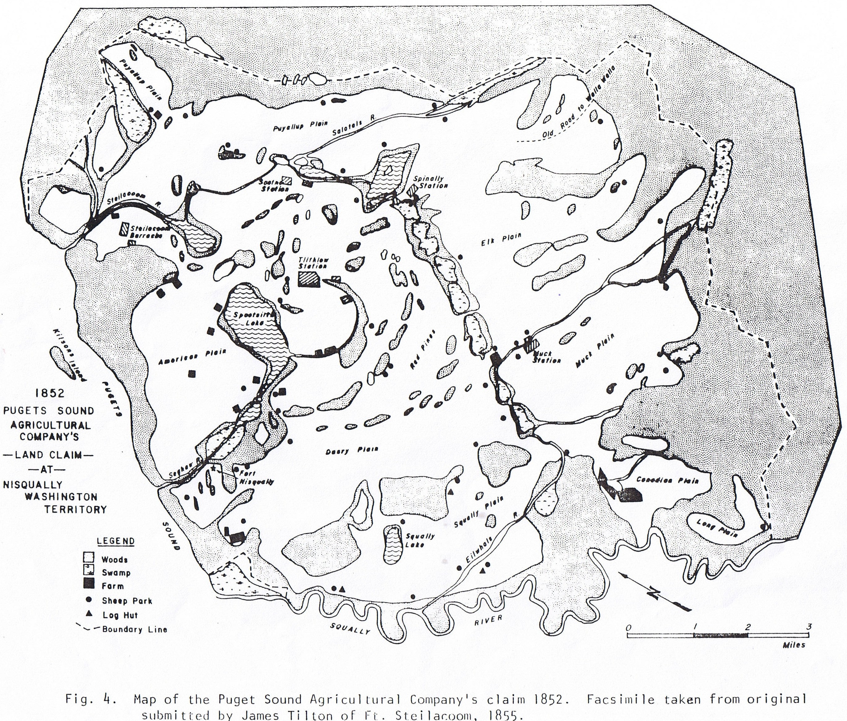
This color map was created by local historian Steve Anderson. He overlayed the Hudson Bay claim map onto a satellite map. There were necessary adjustments as the map maker, an American skewed many locations, possibly to make the area look like is covered less acreage than it actually did. The other two are historic versions of the HBC claim map.
The Nisqually Tribe supplied this map with their sign up for the Leschi Quiemuth Honor Walk. Leschi and Quiemuth were brothers selected by the Nisqually Tribe to participate in the presentation and signing of the Medicine Creek Treaty in December 1854. It is said they refused to sign because the offered reservation was a completely unacceptable location. That Treaty led to a war and a later agreement to a different reservation location, but it also led to their deaths. The light green portion of that reservation was taken from the Nisqually Tribe when Fort Lewis was created. Many settlers also lost their farms. The Honor Walk was created to allow the Tribe to annually revisit their sites on the base.
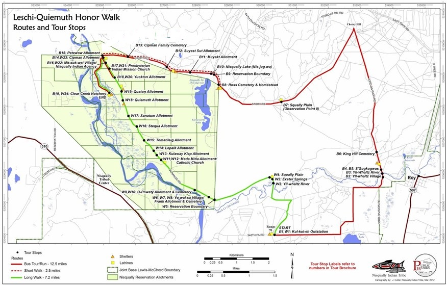
The village, west of Roy, is a stop on the Honor Walk. It was called S’Gugkugwas. The area is lush with Garry Oak, and fields of camas flowers that are usually blooming in May during the visit.
There is much more to tell and there are a few books written about this area. Most notably, The History of Pierce County, by William Bonney 1927. Other authors include, Hope Cecilia Svinth Carpenter, Theodore Winthrop, Steven A. Anderson, Drew W. Crooks, Clarence B. Bagley, Marian Smith, and Nancy Marguerite Anderson. Various Washington State History Journals also have stories of the pre-statehood and settler migrations into the area. Many can be accessed online, along with digital archives or census and other records.
Visits to the prairie of South Pierce County in the Spring often yield marvelous views of Mount Rainier, along with prolific native wild flowers. Since JBLM started burning sections of the prairie in “prescribed burns,” the Scotch broom has been pushed back to reveal these beautiful gems. JBLM has a process to obtain a range pass in order to visit these areas when they are not being used for training.

Roy has the greatest need for youth now so I’m working with the BSD again to take a youth project there 2 days a week there in the fall. Plus Spanaway lutheran has just lost their after school program (BASE) and said why not start a senior center there so told Jani Hutchison who said she’d support such a project. Carol
Did BASE move to the old Naches Trail Elementary building? They are now calling it a community center…